I've always been fascinated by the sky. I'm very curious about Outer Space, very interested in weather, and very observant when it comes to clouds. Something about how they are always different blows my mind. I can remember back in the second grade when we had to make a "cloud cube". I was NEVER an artistic person, and it was the only art-related project I did all by myself and received a decent grade.
On each side, a different cloud type would be shown with a creative way of showing it. For example, cirrus clouds, (the thin, wispy clouds) were shown by torn apart cotton balls. I had a blast making the cube, and ever since then have always enjoyed cloud watching.

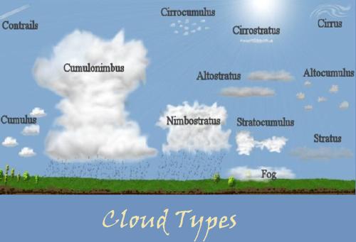
This is a chart that shows the many common cloud types. They are shown very close to what they actually look like, and their heights are accurate. Some of you might be looking at this thinking, "What's so cool about clouds?" I admit it might be a boring topic, but that's only if YOU choose to make it one. The reason I like clouds is because they help predict the weather. If you'd also like to learn how to identify the clouds and what they mean, I'd suggest looking at this chart I made.
Cirrus Clouds
Appearance: Thin, wispy strands of clouds that are often very high up.
Forecast: These usually mean a change in weather will happen. More than likely, a storm might be rolling in throughout the next days.
Altitude: Above 7000 M (23000 FT)
Cumulus Clouds
Appearance: Large, very puffy white clouds.
Forecast: Fair weather will be in store.
Altitude: Below 2000 M (6500 FT)
Stratus Clouds
Appearance: A thick, usually shapeless massive cloud that blankets the sky. It's usually gray.
Forecast: Minor precipitation might be in store.
Altitude: Below 2000 M (6000 FT)
Fog
Appearance: A very low mass of water vapor that has condensed.
Forecast: Usually the outcome of excess moisture in the air.
Altitude: Anywhere from 1000 M to 10 M
Cumulonimbus Clouds
Appearance: Very tall clouds that form from Cumulus clouds.
Forecast: Anywhere from a sprinkle to an intense shower is in store.
Altitude: 2000 M-16000 M (6500 FT-60000 FT)
Nimbus Clouds
Appearance: Dark, often large clouds that are found in thunder storms.
Forecast: Rain, snow, hail, or lightening are all possible.
Altitude: 2400 M (8000 FT)
Author's Note: Sources: www.wikipedia.org
http://commons.wikimedia.org/wiki/File:Cloud_types.jpg